第24页
- 第1页
- 第2页
- 第3页
- 第4页
- 第5页
- 第6页
- 第7页
- 第8页
- 第9页
- 第10页
- 第11页
- 第12页
- 第13页
- 第14页
- 第15页
- 第16页
- 第17页
- 第18页
- 第19页
- 第20页
- 第21页
- 第22页
- 第23页
- 第24页
- 第25页
- 第26页
- 第27页
- 第28页
- 第29页
- 第30页
- 第31页
- 第32页
- 第33页
- 第34页
- 第35页
- 第36页
- 第37页
- 第38页
- 第39页
- 第40页
- 第41页
- 第42页
- 第43页
- 第44页
- 第45页
- 第46页
- 第47页
- 第48页
- 第49页
- 第50页
- 第51页
- 第52页
- 第53页
- 第54页
- 第55页
- 第56页
- 第57页
- 第58页
- 第59页
- 第60页
- 第61页
- 第62页
- 第63页
- 第64页
- 第65页
- 第66页
- 第67页
- 第68页
- 第69页
- 第70页
- 第71页
- 第72页
- 第73页
- 第74页
- 第75页
- 第76页
- 第77页
- 第78页
- 第79页
- 第80页
- 第81页
- 第82页
- 第83页
- 第84页
- 第85页
- 第86页
- 第87页
- 第88页
- 第89页
- 第90页
- 第91页
- 第92页
- 第93页
- 第94页
- 第95页
- 第96页
- 第97页
- 第98页
- 第99页
- 第100页
- 第101页
- 第102页
- 第103页
- 第104页
- 第105页
- 第106页
- 第107页
- 第108页
- 第109页
- 第110页
- 第111页
- 第112页
- 第113页
- 第114页
- 第115页
- 第116页
- 第117页
- 第118页
- 第119页
- 第120页
- 第121页
- 第122页
- 第123页
- 第124页
- 第125页
- 第126页
- 第127页
- 第128页
- 第129页
- 第130页
- 第131页
- 第132页
- 第133页
- 第134页
- 第135页
- 第136页
- 第137页
- 第138页
- 第139页
- 第140页
- 第141页
- 第142页
- 第143页
- 第144页
- 第145页
- 第146页
- 第147页
- 第148页
- 第149页
- 第150页
- 第151页
- 第152页
- 第153页
- 第154页
- 第155页
- 第156页
- 第157页
- 第158页
- 第159页
- 第160页
- 第161页
- 第162页
- 第163页
- 第164页
- 第165页
- 第166页
- 第167页
- 第168页
- 第169页
- 第170页
- 第171页
- 第172页
- 第173页
- 第174页
- 第175页
- 第176页
- 第177页
- 第178页
- 第179页
- 第180页
- 第181页
- 第182页
- 第183页
- 第184页
- 第185页
- 第186页
- 第187页
- 第188页
Ⅳ. 任务型阅读(每题1分,满分10分)
阅读下面的短文,并根据所读内容在文章后表格中的空格里填入一个最恰当的单词。(每空一词)
逐题讲解
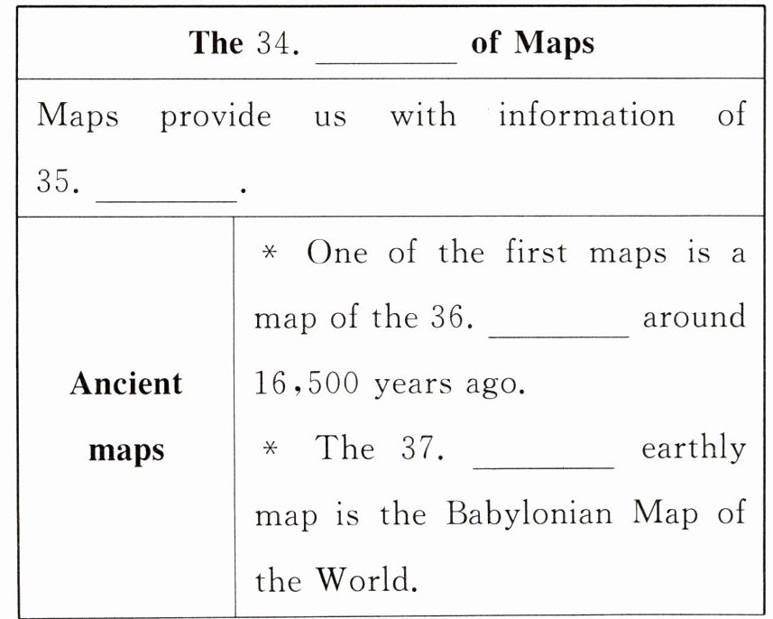
Maps mark(标记) seas, countries, cities and our homes, and guide us through the world. To know them better, let’s take a look at how maps have changed over the centuries.
Many ancient countries used maps. One of the first is thought to have been drawn on the wall in Lascaux, France, around 16,500 years ago. Hidden among the drawings of birds and bulls(公牛)is a map of the stars. The Babylonian Map of the World is the oldest known earthly map, which shows Babylon and its neighbouring towns on the stone.
Claudius Ptolemy made maps go worldwide. Born in Egypt around 100 CE, he was the first person to try to make a world map. With the help of maths, Ptolemy marked around 10,000 locations from Britain to Asia and Africa.
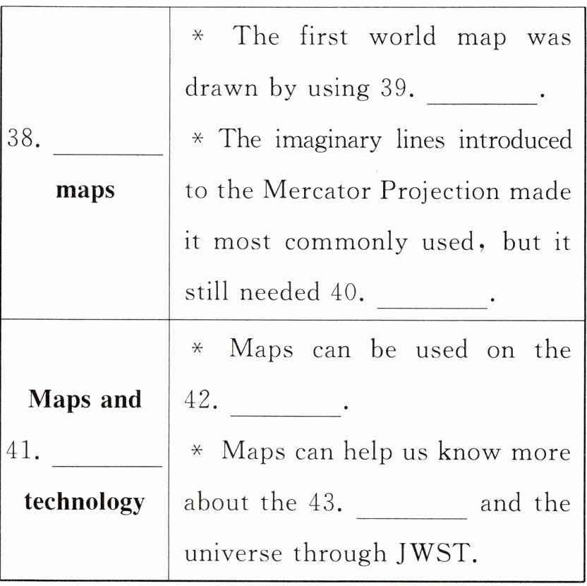
Perhaps the most commonly used world map is the Mercator Projection. It was introduced in 1569 by Gerardus Mercator. An important part of maps is the imaginary(假想的)lines of longitude, latitude and the equator(赤道).
Mercator took the globe and made it flat(平的), but to do this, he had to make the areas further north and south larger, while the areas nearer the middle stay about the right size. The reason for this is that the Earth is like a ball, but a map is flat. It is easy to find places, but some people said it was unfair because places including Canada, the UK and Europe appeared much bigger than they really were.
In the 19th and 20th centuries, modern technology allowed map makers to produce maps showing locations exactly. Today, many people view maps on their phones. Researchers are working to map the floor of the oceans and to locate every tree on the Earth. Scientists are also trying to map the past by using the James Webb Space Telescope(JWST). This invention will collect light from stars and may find the secrets about the beginning of the universe(宇宙).
阅读下面的短文,并根据所读内容在文章后表格中的空格里填入一个最恰当的单词。(每空一词)
逐题讲解
Maps mark(标记) seas, countries, cities and our homes, and guide us through the world. To know them better, let’s take a look at how maps have changed over the centuries.
Many ancient countries used maps. One of the first is thought to have been drawn on the wall in Lascaux, France, around 16,500 years ago. Hidden among the drawings of birds and bulls(公牛)is a map of the stars. The Babylonian Map of the World is the oldest known earthly map, which shows Babylon and its neighbouring towns on the stone.
Claudius Ptolemy made maps go worldwide. Born in Egypt around 100 CE, he was the first person to try to make a world map. With the help of maths, Ptolemy marked around 10,000 locations from Britain to Asia and Africa.
Perhaps the most commonly used world map is the Mercator Projection. It was introduced in 1569 by Gerardus Mercator. An important part of maps is the imaginary(假想的)lines of longitude, latitude and the equator(赤道).
Mercator took the globe and made it flat(平的), but to do this, he had to make the areas further north and south larger, while the areas nearer the middle stay about the right size. The reason for this is that the Earth is like a ball, but a map is flat. It is easy to find places, but some people said it was unfair because places including Canada, the UK and Europe appeared much bigger than they really were.
In the 19th and 20th centuries, modern technology allowed map makers to produce maps showing locations exactly. Today, many people view maps on their phones. Researchers are working to map the floor of the oceans and to locate every tree on the Earth. Scientists are also trying to map the past by using the James Webb Space Telescope(JWST). This invention will collect light from stars and may find the secrets about the beginning of the universe(宇宙).
答案:
Ⅳ. [文章大意]本文是一篇说明文,主要介绍了地图的发展历程。
34. History/Development/Changes 35. geography 36. stars
37. oldest 38. World 39. maths 40. improvement/improving
41. modern 42. phone 43. Earth
34. History/Development/Changes 35. geography 36. stars
37. oldest 38. World 39. maths 40. improvement/improving
41. modern 42. phone 43. Earth
查看更多完整答案,请扫码查看